Mapping the Parishes
In Louisiana, instead of calling them counties, they call them parishes. Some of them have religious sounding names, but don't think of them as churches. Think of them as counties.
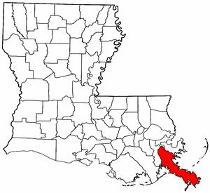
On this map, Plaquemines Parish is in red. Jefferson Parish is to its west, St. Bernard Parish to its northeast, and Orleans Parish between the two.
Lafourche Parish is the large one to the southwest of Jeff Parish.
Lake Pontchartrain is north of Jeff and Orleans parishes.
St. Tammany Parish is opposite Orleans Parish, on the north shore of the lake. Washington Parish is to the north of St. Tammany; Tangipahoa Parish is to the west of those.
Cities by parish:
Orleans Parish: New Orleans
Jefferson Parish: Metairie, Kenner (home of the airport)
Lafourche Parish: Thibodaux, Port Fourchon
St. Tammany Parish: Covington, Slidell
St. Bernard Parish: Chalmette, Arabi, Violet
Plaquemines Parish: Belle Chasse, Pointe a la Hache, Pilottown
Washington Parish: Franklinton, Bogalusa
Tangipahoa Parish: Hammond, Kentwood, Ponchatoula
And about the river:
In south Louisiana, the sides of the Mississippi River are often referred to as East Bank and West Bank. In New Orleans, we'd refer to the cities across the river as the West Bank, even though they were due south of much of the city.
Jeff Parish includes cities on both banks (the airport is on the East Bank). The river delta splits into multiple branches just downriver from Pilottown (in Plaquemines), a major entry/exit point for ships bearing every kind of cargo.
posted by BT at 4:36 PM
![]()

0 Comments:
Post a Comment
<< Home